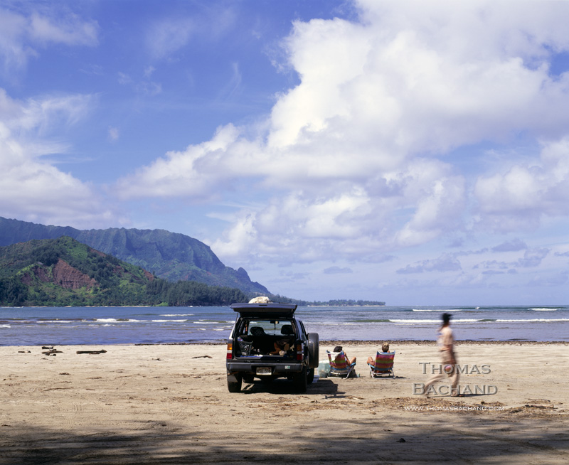
Beach-goers. Hanalei, Kauai.
Editorial photography from the islands. For a closer look at my editorial work, visit my editorial portfolio.
Registered © Thomas Bachand. All Rights Reserved.
Beach-goers. Hanalei, Kauai.
Editorial photography from the islands. For a closer look at my editorial work, visit my editorial portfolio.
Registered © Thomas Bachand. All Rights Reserved.
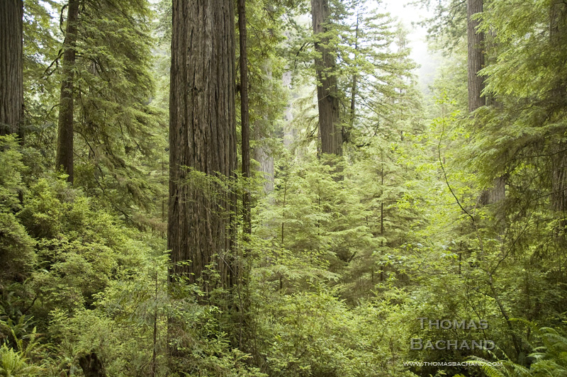
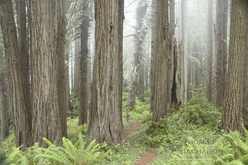
Rain. Forest. Redwood National Park.
Part of my new series, Old Growth, this work explores California’s redwood forests and the enigma of old growth. We treasure these primal forests, yet less than five percent remain. For the remainder of this week and periodically in the coming months I will be releasing new images.
Registered © Thomas Bachand. All Rights Reserved.
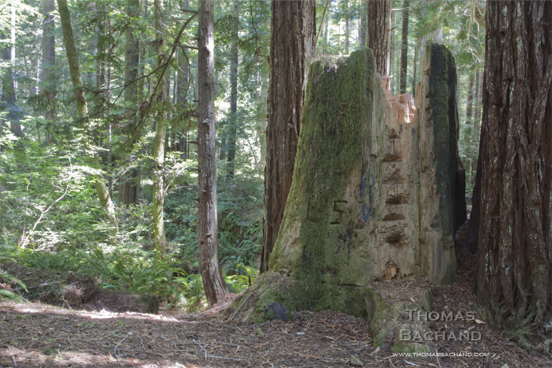
Ladder. Jackson Demonstration Forest.
Part of my new series, Old Growth, this work explores California’s redwood forests and the enigma of old growth. We treasure these primal forests, yet less than five percent remain. For the remainder of this week and periodically in the coming months I will be releasing new images.
Registered © Thomas Bachand. All Rights Reserved.
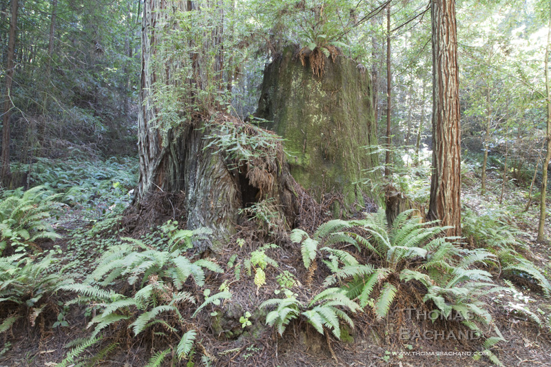
Stump & Ferns. Jackson Demonstration Forest.
Part of my new series, Old Growth, this work explores California’s redwood forests and the enigma of old growth. We treasure these primal forests, yet less than five percent remain. For the remainder of this week and periodically in the coming months I will be releasing new images.
Registered © Thomas Bachand. All Rights Reserved.
Backpacker. Redwood National Park. California.
Today I will begin showing, for the first time, photographs from my Old Growth series. This work explores California’s redwood forests and the enigma of old growth. We treasure these primal forests, yet less than five percent remain. For the remainder of this week and periodically in the coming months I will be releasing new images.
Registered © Thomas Bachand. All Rights Reserved.

Boats illegally moored to beach. Sugar Pine Point State Park. July 2, 2011
It’s become common knowledge that invasive species are a significant threat to Lake Tahoe’s ecosystem and water quality. The Tahoe Environmental Research Center offers an overview on the lake’s invasive species and history on their website. Given that invasive species are most commonly introduced into the lake by boaters and occur in greater concentrations near marinas, it is perplexing that the boating community is not making a greater effort to protect Lake Tahoe.
While the boating community is to be commended for getting on board with invasive species boat inspections in a single year, there is ample opportunity for boaters to be proactive and to mitigate their effects on Tahoe. Lakefront property owners obstruct views and access with their piers and buoys. Boat noise is a constant din during summer. Once a boat is launched into the lake, it enjoys free use of the entire lake. Even where boating restrictions exist, short staffing at parks and sheriff departments hinders enforcement.
The photograph above shows a typical summer day at Sugar Pine Point State Park where boaters illegally beach their boats, effectively prohibiting paying park users from swimming or walking along the shore. The park claims that they do not have the staffing to patrol the beach. In effect, the non-paying park users prevent legitimate park patrons from using the beach. If the park is unable to properly monitor a given activity, it should be banned altogether instead of allowed to persist unabated.
It is perplexing as to why boaters are not paying the annual state parks use pass fee (plus additional camping fees when applicable) for water access to California’s parks. In addition, it only seems appropriate that boaters should pay additional fees to fund ongoing invasive species eradication programs. These fees could easily be assessed when boat owners register their boats and submit to inspections.
By paying their way, boaters would strengthen stewardship of Lake Tahoe instead of weakening it by overtaxing already strained resources. The funds would go a long way towards keeping parks adequately staffed and increasing the protection of this national treasure.
If you agree with these sentiments, send an email Susan Grove (sgrove@parks.ca.gov), Superintendent at the California Department of Parks and Recreation, Lake Tahoe Sector, Sierra District. Please CC the League to Save Lake Tahoe (info@keeptahoeblue.org).

Truckee Meadow. South Lake Tahoe, California
More than that of leaves changing colors, Fall in the Sierra is a time of golden grasses. Above, the Upper Truckee River meanders toward the shore of Lake Tahoe.
This meadow is part of the largest wetland in the Tahoe basin, stretching back several miles along Highway 50 towards Echo Summit. In the last half century this area has seen dramatic changes. Christopher Soulard and Christian Raumann of the United States Geological Survey have compiled historic orthoimagery data on South Lake Tahoe, of which this meadow, being adjacent to Tahoe Keys, is of particular note. In fact, Google Earth used the USGS Tahoe data for its first historical imagery sample (read about it in the New York Times). The dredging of Tahoe Keys has created some of the most dramatic environmental damage to the Tahoe ecosystem.

Riverbank. Upper Truckee Meadow. South Lake Tahoe, California.
Today, the Upper Truckee is the focus of major environmental restoration. Of primary concern is a golf course that restricts and narrows the river’s flow and is a significant source of sedimentation into the lake. Over the last twenty years the realignment of the river through the golf course has, in some parts, eroded 50 feet of the embankment. The current plan calls for moving the golf course into undisturbed neighboring lands in Washoe Meadows State Park so as to restore the river’s natural flow and its adjoining riparian habitat. This plan has upset both golfers, who are concerned about increased course fees, and environmentalists, who wish to protect surrounding forest lands. The park enjoys the golf revenue and says that the forest land to be offset by the golf course is not endangered habitat and is scarcely used (by humans). Now that I know the park is there, I’ll go visit it. Just sayin’.
Read about the Upper Truckee restoration in the Sacramento Bee here. The Upper Truckee Restoration EIR and other project information can be found here.

Lake Tahoe from edge of pier. Sugar Pine Point State Park. California.
A couple of years ago on a warm, mid-summer day, we launched our kayak onto Rubicon Bay’s clear and smooth waters – so clear, it felt as if we were flying over the rippled sands 20 to 30 feet beneath Tahoe’s surface. Paddling toward deeper water, the sandbar suddenly ended and the lake bottom plunged into the darkened depths. As if suspended, we felt a sense of vertigo.
This year, after Labor Day, we returned once again to “fly” above Rubicon’s sandy bottom. To our dismay, the waters were clouded, the lake bottom detail indistinguishable and, as we paddled into deeper water, the green of the shallows simply faded to the black of the depths. To quote Marlin from Finding Nemo, “Good feeling gone.”
Following the publication of the 2011 State of the Lake Report by the Tahoe Environmental Research Center and its finding that lake clarity dropped by four feet in 2010 (to 64 feet), there were a number of articles on current conditions at Tahoe (UC Davis, Los Angeles Times, KQED). In recent decades Tahoe research has become increasingly sophisticated and comprehensive. While the Secchi disk depth-visibility measurement continues to be the benchmark on clarity, today, a more broad set of factors are being examined, including stream runoff, road dust, lake temperature and mixing, invasive species, forest conditions, and remote sensing data. It is clearly understood that Tahoe’s problems circulate with the waters and are not confined by borders. My summer Rubicon excursion leads me to believe that next year’s State of the Lake report will detail a steeper decline in clarity.
The buried lead in the report is that, just as the lake knows no borders, our political approach must not either. The authors underscore the need for continued cooperation between California and Nevada (i.e. support for the Tahoe Regional Planning Agency – TRPA). Meanwhile, the media has given little attention to Nevada’s intent to pull out of TRPA. The state feels the bi-state agency hinders development. Many of us find this odd as TRPA exhibits a pro-developer bias and has yet to turn down a major project. Regardless, California’s politicians are scrambling to negotiate with Nevada. Nevada’s tactics are familiar: invent a crisis whose resolution serves your special interest.
Lake Tahoe now finds itself the latest target of the deregulators and science deniers.

Rebirth. Mountain Blvd. Aftermath Oakland Firestorm 1991.
On this twentieth anniversary of the Oakland Firestorm I am revisiting my photography and writing created around the time of the catastrophe.
I have put together a web page that contains 36 images shot during and after the fire, an essay on the events of that day, and the introduction to Lake Tahoe: A Fragile Beauty, where I discuss our relationship with fire.
http://www.thomasbachand.com/oakland_firestorm/
Feel free to pass it along.

Median Tree. Seaside, California.
Just a reminder that photo submissions for Managed Landscapes at the Vermont Photo Space Gallery are closing soon.
The touch of man on the natural landscape is all around us. From shimmering cityscapes and rural farms to strip mines and garbage dumps. Let’s see images that show the touch of man, light or heavy, on the earth around us.
I’m the sole juror for this show and look forward to seeing interesting work.